Frequently Asked Questions
These are questions Protect Mud Bay Cliffs is frequently asked. If you have a question that is not addressed, please visit the Contact Us page, and let us know.
1. What are the Mud Bay Cliffs, and where are they located?
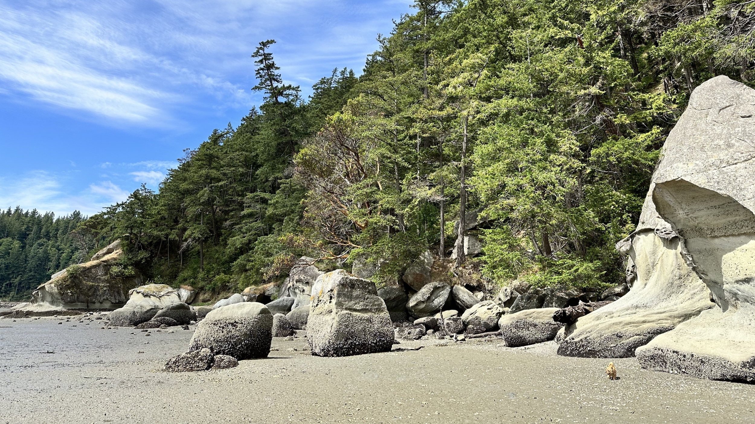
Mud Bay Cliffs refers to the steep, forested cliffs rising above Mud Bay (aka North Chuckanut Bay), the shoreline along the bay at the base of the cliffs, and the mature woodlands and wetlands which crown the cliffs. This natural, undeveloped area is home to diverse wildlife; one of Bellingham’s important Wildlife Corridors runs through it — and this site is designated an Important Habitat Hub. Mud Bay Cliffs consists of both private property and public shoreline. It is a coastal watershed draining directly into Mud Bay, the City of Bellingham’s most biologically diverse pocket estuary and estuarine wetlands. These ecologically sensitive lands and wetlands, which encompass interconnected public and private spaces, are a unique Bellingham gem.
2. Is PMBC opposed to development? Won’t the city make sure that the developers do things the right way?
PMBC and its members are not opposed to development. Property owners, Bellingham City staff, and Public Citizens all have a vested interest in ensuring responsible development.
Citizens have always played a vital role in ensuring our municipality adheres to all applicable codes, regulations, and laws. The citizens’ role was vital to ensure protection of both the Chuckanut Ridge - Hundred Acre Wood property and Governors Point.
Because the public’s role is so important, the city process includes designated Public Comment periods and opportunities. Our voices are vital to protect the public interest. Our engagement is crucial because our busy city planners have constrained capacity to investigate complex and challenging development proposals. The city relies on input from both developers and citizens.
3. Isn’t more housing in Bellingham a good thing?
Yes, Bellingham would benefit from more affordable housing. However, the developer has stated The Woods at Viewcrest would be “high income” housing — that is, it would result in construction of homes, condominiums, and/or townhomes for “high income” owners (the developer’s SEPA Checklist designates the subdivision as “high income”).
Citizens have an interest in affordable housing; we also have an interest in the protection of public safety and public assets. No one will benefit from a risky housing development on unstable slopes with the potential to impose significant adverse impacts on the environment, wildlife, the public who recreate in this area, and those who live nearby. The citizens of Bellingham will not benefit if the many protected ecosystems and publicly-owned assets surrounding the private land are harmed by poorly-planned subdivision development. These include: Clark’s Point; the public shoreline below the proposed subdivision; the Mud Bay estuarine wetlands; Chuckanut Marsh; Chuckanut Creek; the Post Point Great Blue Heron Colony. These public assets are connected by wildlife corridors, forming a Habitat Network; the site of the proposed subdivision is the only unprotected Important Habitat Hub in the network. The citizens of Bellingham have a right to expect the city will protect our investment of taxpayer dollars in these public assets, and the intended purpose of many of those investments: protection of Salmon, Great Blue Herons, and other wildlife which rely on these fragile, already fragmented and challenged habitats.
4. Is there any hope that PMBC can actually make a difference?
We already have made a difference; our communications with the city appear to have informed portions of the city’s formal “Requests for Information” from the developer. Going forward, we – and the technical experts we hire – expect to have even greater impact, with the support of this concerned community. Remember: other important natural spaces here in Bellingham have been protected before by ensuring applicable laws and regulations are followed, and together, we can do it again.
5. Three members of the Jones family who own the property sent a letter to south-side residents about the project in late 2022, and sounded reassuring – is PMBC over-reacting?
PMBC bases our actions on the actual application materials, which are what the city Planning Department is allowed to consider. Based on those 800-plus-pages of plans, requests, and reports, ours is not an over-reaction at all: far from it. We understand few of us have the time or expertise to review the voluminous, often technical, application materials. That is why we are volunteering our time, and why we are retaining and hiring technical experts. Should the application materials at some point all come into compliance with all local, state and federal regulations, no one will be more pleased than PMBC. At present, however, the application contains significant deficiencies and is a long way from that level of completeness and compliance.
For more information, PMBC’s 12/2022 response to the developers’ 12/2022 letter can be viewed here: https://mudbaycliffs.org/updates/updates-and-comments-on-developers-12822-letter .
Additionally, PMBC’s 6/28/2023 letter to Bellingham Planning Department Director Blake Lyon regarding the application’s deficiencies can be viewed here: https://www.scribd.com/document/658247191/Protect-Mud-Bay-Cliffs-Letter-Woods-at-Viewcrest-Third-Request-for-Information# . PMBC has also submitted multiple Public Comment documents into the administrative record, documenting the numerous deficiencies and areas of non-compliance in the project proposal.
6. How is this even a thing?!? How can something like this even be up for potential approval?
We hear this question often, and most frequently from citizens who’ve resided in other states and municipalities which have stronger regulations to protect the environment and wildlife. Bellingham’s environmental and wildlife protections are very different from what many of us have enjoyed elsewhere, and is even more reason to take action on this project now – and then bolster city codes for the future.
Property owners have the right to apply for permits to subdivide their land. The city’s role is to ensure all applications comply with current development regulations, including the protection of public health, safety, and welfare. We note that the city is not obligated to give the developers special variances to municipal code, nor to cede existing public right-of-way.
7. What are some of the geological hazards PMBC is concerned about?
Geologically unstable sites such as this one are prone to landslides, erosion, and seismic events, which is confirmed by the developers’ current geological study itself.
Recent news such as this, for example:
https://www.abc4.com/news/wasatch-front/two-houses-slide-off-hill-collapsing-in-draper/
reminds us what can happen when homes are built on sites with significant geohazards, even when developers claim to have planned for public safety. Unstable local substrates, combined with effects from water, gravity, and weather over time, can be powerful in combination. For Public Safety reasons, PMBC believes the geotechnical study needs to go into much more detail than it currently does. Indeed, the developer’s current geotechnical study itself recommends a lot-by-lot analysis, because it is only a “feasibility”-level study. And it is important to note that the proposed project currently puts building lots adjacent to Landslide and Erosion Hazards Areas without the buffer required by Bellingham’s regulations. All of this is concerning – and unnecessary.
More detail about the geohazards of this site: To evaluate the potential impacts of this project, on both the private land and the public areas and waters, it’s important to consider the geologically hazardous areas that exist within the 38-acre parcel. Below are direct quotes from the 12/31/09 Geologic Feasibility Investigation of this site. Given these geologically hazardous areas, it seems clear that the proposed subdivision would impose significant impacts on the environment:
“The site was observed to consist of ridge or cliff forming units of Chuckanut Formation Sandstone.
In addition to steep topography, several vertical or near vertical bedrock cliffs were observed across the site.
Portions of the site have been identified as having High Landslide Potential in that they have slopes greater than 30%, slopes exceeding 80%, and slopes greater than 15% that may be potentially unstable because of other factors.
Seismic induced slope failure and rock fall are possible at this site.
Field observations suggest that the soils on the project site have a relatively low susceptibility to erosion in an undisturbed state because of dense vegetation, but that alteration of these conditions could significantly increase the erosion potential.
Future development of the site could impact the current hydrologic condition… Changes in hydrology can alter the probability, frequency and magnitude of mass wasting (landslide) activity.
Development on or above steep slopes could impact slope stability by changing surface or groundwater flow on the slopes. In addition, the risk of landslides could be impacted by construction near or on steep slopes because of grading disturbance or additional load application from structures such as buildings, road fill embankments, topographic alterations or retaining walls.
Because of the steep slopes and existing groundwater conditions, modifications of groundwater or surface water flow may impact the potential size and frequency of mass wasting (landslide) events. The fine-grained soils found on site are susceptible to soil erosion resulting from the movement of heavy equipment or site grading.”
8. Why are there concerns about Stormwater drainage?
The developers’ claims about stormwater management cannot be verified because their stormwater management report is currently missing the required calculations for the proposed Modular Wetland Systems (MWS).
What we do know is that discharges from modular wetland systems are anything but clean. The most commonly used devices have been tested for their efficacy on removing pollutants. These systems only remove 45% of nitrogen and 64% of total phosphorus. Nitrogen and phosphorus are directly linked to low dissolved oxygen levels in receiving waters, and these are the primary pollutants associated with nearby Chuckanut Creek and the Mud Bay estuarine wetlands. PMBC believes the current project plans are inadequate and raise significant concerns, and that without substantive revision there is likely to be significant impact to wildlife (including salmon, great blue herons, shellfish and other estuarine wetlands species).
Developing just the roads and other infrastructure of this ecologically-sensitive mature woodlands will require extremely difficult and time-consuming excavation of the shallow bedrock with powerful, rock-breaking equipment.
All of the land clearing, grading and excavation will permanently alter the flow of both surface and subsurface stormwater, and will greatly increase the probability, frequency and magnitude of landslide activity, erosion, and earthquake-induced slope failure and rock fall. Indeed, the situation on this site is so precarious that blasting is considered too dangerous to even recommend.
The developer has not provided a Hydrology assessment of how the alterations to the site will change the drainage from the site into the surrounding ecosystems.
In addition, the developer’s current plan calls for a large portion of stormwater to drain into an existing city stormwater drainage system. This city system is currently deficient and non-compliant – and its polluted outflow is directly into the Mud Bay estuarine wetlands. Longtime neighbors observe that where eel grass once grew plentifully near the outflow site, since the stormwater outflow was introduced the eel grass has disappeared. The Mud Bay estuarine wetlands have suffered from pollution for years, and adding more polluted runoff would worsen an already challenged estuarine wildlife habitat.
9. What are some of the variances to municipal codes and public rights which the developers have asked for?
The developers asked the City of Bellingham to give up an existing Public Right-of-Way on the site. The city has already agreed to cede this Public asset to the private developers, if the proposed project is ultimately approved (this recommendation was made without public input). PMBC believes this is NOT in the public’s interest, simply to enrich private parties. Moreover, if the city were to decide to cede this public asset, PMBC believes the city should request public input to what counter-balancing asset is granted the public in return, and not simply accept the developers’ preferred option.
In addition, the developers have requested variances, and ‘discretionary allowances’ from the city, which are in conflict with the city’s regulations. PMBC believes these variances are not in the public’s interest. PMBC does not support the city granting special permissions and variances simply to enrich property owners, at the expense of public interests such as safety, recreation, and environmental protections of public shoreline and estuarine wetlands. For example:
The currently proposed roads and utilities infrastructure do not comply with city regulations, and require the developers to apply for variances of the law as part of their application. The long, narrow private roads and driveways the developers propose will make access by emergency and firefighting equipment difficult and potentially more dangerous, creating Public Safety risks.
The developer is asking for variances to building envelope requirements around hazardous areas. This can create public safety risks during building and for decades beyond, as erosion and greater instability can result in rockfall, wasting, and landslide.
10. Would this development affect the Post Point Great Blue Heron colony?
This location is a primary and vitally important feeding resource and sheltering location for the Post Point Great Blue Heron colony. PMBC believes it is likely that the Post Point Great Blue Heron colony would be negatively impacted because:
Development of the roads and other infrastructure, as well as the eventual homes built over time, can be expected to disturb this colony, which was originally located on Chuckanut Bay and fled to Post Point because of subdivision development on Chuckanut Bay.
The current stormwater management plan appears deficient and likely to introduce pollutants into the heron’s feeding zone. Increasingly polluted water will affect both the food supply and the heron’s health through exposure while hunting in the Mud Bay estuarine wetlands.
Landslides and erosion related to development can be expected to introduce additional water quality issues.
Loss of trees related to development and vegetation degradation will negatively impact sheltering and roosting at this location.
Great Blue Herons prefer to feed their young from estuaries within three miles of their nests. The Mud Bay estuarine wetlands are the most biologically rich and diverse in all of Bellingham, and are about one-and-a-third miles from the Post Point nests. Because Mud Bay is a primary and vitally important feeding resource for these heron families, visitors are delighted by regular sightings of numbers of these extraordinary birds.
The Post Point heronry is the last known remaining nesting colony of Great Blue Herons in the City of Bellingham; the former Chuckanut Bay nesting colony was abandoned in 1999, during construction of Blue Heron Estates. A subset of those herons relocated to Post Point, after which the City of Bellingham, with strong public support, has made large investments to help the Post Point colony thrive.
It seems likely that IF this subdivision is approved by the Planning Department, development activities – including road grading, road building, excavation work, pile-driving, and more – will disrupt the Post Point colony. Moreover, rockfall and wasting may also affect the colony, as may stormwater runoff (much of which will escape stormwater management systems) as estuarine water quality is negatively impacted by pollutants. The herons rely on a thriving Mud Bay estuarine wetlands, and PMBC believes it is folly to unnecessarily risk all the species which share that reliance, from herons to salmon to shellfish, and more.
11. What is “Protect Mud Bay Cliffs”?
We are an all-volunteer, grassroots group of Bellingham citizens who are concerned about public safety, recreation, and protection of the extremely complex environment of Mud Bay Cliffs, including fish and wildlife habitats. The larger PMBC group includes over 1,000 signers of a Petition submitted to the city as part of the Public Comment period.
Our goal is to minimize the negative impacts of this proposed subdivision by ensuring it complies with important codes, laws, and safeguards.
We came together a couple of years ago – shortly after the developer’s February 2021 pre-application neighborhood meeting – and have been working diligently to protect this treasured, ecologically-sensitive site and adjacent public lands, shoreline, and estuarine wetlands from unnecessary development risks. Every one of us willingly volunteers our time and expertise.
Most individual concerned members of the public lack the time to track the city’s multi-year process and the developers’ changing plans and claims. PMBC’s volunteers work to provide an ongoing focus to help augment the public’s tracking and review of this proposal. PMBC helps increase public awareness of key issues and developments; reviews — and hires experts to review — developers’ plans and reports; and communicates with city officials about key concerns. (PMBC does not, and cannot, replace the city’s nor the developers’ communication responsibilities; PMBC does not claim to represent the voices or perspectives of all concerned citizens.) We encourage all members of the public to follow the city Planning Department’s process and progress at the city’s website for this proposed project (https://cob.org/project/the-woods-at-viewcrest ).
Protect Mud Bay Cliffs is sponsored by Responsible Development, a public charity that is qualified to accept tax-deductible contributions. As many of you know, Responsible Development championed the preservation of the Chuckanut Ridge - Hundred Acre Wood property.
All funds contributed to Responsible Development / Protect Mud Bay Cliffs will be used to protect Mud Bay Cliffs to the greatest extent possible by law. This includes paying for technical and legal expertise to defend public safety, and protect and preserve these ecologically-sensitive lands and wetlands (which encompass interconnected public and private spaces).
12. What can I do to help?
The Public Comment period is open until the city makes decisions on the proposed project. Sign the Petition (see tab in navigation bar), write a letter to the city, and please visit our “Join In” page to donate to support this effort, and more. To stay informed in the future, you can sign up for Updates at the bottom of our Home page. We greatly appreciate the wide-ranging support from concerned citizens and ally organizations across Bellingham!